

2D Building Foot Print
PROJECTS
2D Building Foot Print
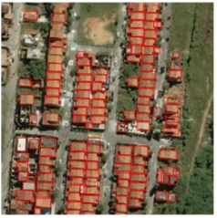
Objective:
Building Data Capture for capturing 2D building footprints, base and hollow parts of building, done by leveraging Automated Tools, Open Source technologies & Satellite imagery. Building features intersecting / Crossing the city etc., with reference to the provided Satellite Imagery Data. The scope was executed for Indian cities.
Inputs Used :
Satellite Imagery Data provided by client.
Software Used :
QGIS.
Output :
Building Layer as Shape file Format.